Description
🧭 Navigate Boldly, Connect Globally, Adventure Fearlessly!
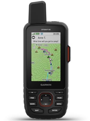
- SOS WHEN IT COUNTS - Trigger interactive SOS alerts monitored 24/7 for peace of mind on every adventure.
- NAVIGATE LIKE A PRO - Preloaded TOPO maps plus Birdseye satellite imagery give you unmatched terrain insight without extra fees.
- ENDURANCE FOR EPIC JOURNEYS - Rechargeable battery powers up to 35 hours in tracking mode or 200 hours in expedition mode—go further, worry less.
- GLOBAL CONNECTIVITY ANYWHERE - Stay linked worldwide with Iridium satellite tech and 2-way messaging—no cell towers needed.
- WEATHER WAYPOINTS ON DEMAND - Access live weather updates and manage routes seamlessly via Garmin Explore app integration.
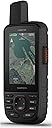
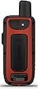
The Garmin GPSMAP 66i is a rugged handheld GPS and satellite communicator featuring a sunlight-readable 3-inch color display, preloaded TOPO maps with Birdseye satellite imagery, and 100% global Iridium satellite network for two-way messaging and SOS alerts. It supports multiple GNSS systems, offers live weather updates, and integrates with the Garmin Explore app for route and waypoint management. With up to 35 hours of battery life in tracking mode and 200 hours in expedition mode, it’s engineered for serious outdoor professionals and adventurers who demand reliable navigation and global connectivity.