
Desert Online General Trading LLC
Dubai, United Arab Emirates
Desert Online General Trading LLC
Dubai, United Arab Emirates
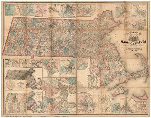
This old map of Massachusetts was published in 1861 by H.F. Walling. The map was compiled from the very detailed county maps made by Walling in the 1850s. It appears to show the location of every house in rural Massachusetts. The map is very accurate, as it was based on the high quality surveying done 20 years earlier by Simeon Borden. The towns, major roads, and coastal features are shown as well as insets of village maps. Included in insets are a climatological map and a geological map of the state. Great for history lovers. Printed at original and reduced sizes. The smallest text is legible at the 36"x46" size but not legible on the 24"x30" size. The town, village, and county names are legible on the 24"x30" size print. (Original size 57"x75") Printed on high quality bond paper.
Trustpilot
2 weeks ago
2 weeks ago